Trail Walking Le Tholonet - Les barrages du Tholonet - Photo
 frizou83
frizou83

User

© OpenStreetMap contributors
Length
Length
13.2 km
Max alt
Max alt
384 m
Uphill gradient
Uphill gradient
460 m
Km-Effort
Km-Effort  
19.3 km
Min alt
Min alt
180 m
Downhill gradient
Downhill gradient
458 m
Boucle
Boucle
Yes
Creation date :
2014-12-10 00:00:00.0
Updated on :
2014-12-10 00:00:00.0

(0 Reviews)

Walking
Walking
4h07
Difficulty : Easy

Scan this QR Code to open this trail in the SityTrail application

FREE GPS app for hiking

Logo SityTrail SityTrail

IGN / Geographical institutes

Download SityTrail from the App Store Download SityTrail from Google Play

Logo SityTrail SityTrail World

The world is yours!

Download SityTrail from the App Store Download SityTrail from Google Play Download SityTrail on Huawei AppGallery

About

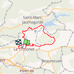
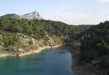
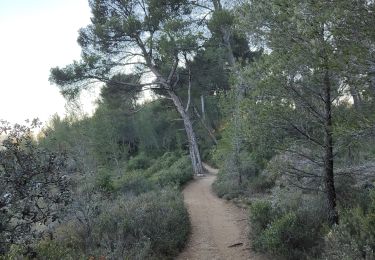
Trail Walking of 13.2 km to be discovered at Provence-Alpes-Côte d'Azur, Bouches-du-Rhône, Le Tholonet. This trail is proposed by frizou83.

Description

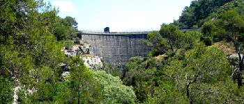
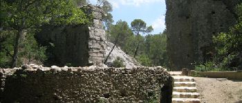
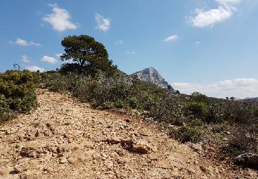
Circuit dans la réserve naturelle de la Sainte-Victoire au départ du Tholonet, en passant par les lacs du Bimont et Zola.

Elevation profile

Photos

Points of interest

Point of interest Beaurecueil - Ancienne carrière - Photo
frizou83
BEAURECUEIL 
Point of interest Beaurecueil - Barrage du Bimont - Photo
frizou83
BEAURECUEIL 
Point of interest Le Tholonet - Barrage Zola - Photo
frizou83
LE THOLONET 
Point of interest Le Tholonet - Barrage Romain - Photo
frizou83
LE THOLONET 

Positioning

Country:
France
Region :
Provence-Alpes-Côte d'Azur
Department/Province :
Bouches-du-Rhône
Municipality :
Le Tholonet
Location:
Unknown
Start:(UTM)
702922 ; 4821869 (31T) N.

Trails nearby

Trail Walking Aix-en-Provence - Circuit des lacs Zola et Bimont - Aix-en-Provence - Photo
Walking
tracegps

Walking

Medium
(4)
Aix-en-Provence, Provence-Alpes-Côte d'Azur, Bouches-du-Rhône, France
10 km | 13.6 km-effort
2h 30min
Yes
Trail Walking Saint-Marc-Jaumegarde - Barrages Zola-Bimont - Photo
Walking
Berpav

Walking

Medium
(2)
Saint-Marc-Jaumegarde, Provence-Alpes-Côte d'Azur, Bouches-du-Rhône, France
8 km | 11 km-effort
2h 30min
Yes
Trail Walking Saint-Marc-Jaumegarde - La Croix de Provence depuis le barrage de Bimont - Photo
Walking
tracegps

Walking

Difficult
(1)
Saint-Marc-Jaumegarde, Provence-Alpes-Côte d'Azur, Bouches-du-Rhône, France
13.9 km | 24 km-effort
4h 45min
Yes
Trail On foot Beaurecueil - Sentier Imoucha - Photo
On foot
PRO

On foot

Easy
Beaurecueil, Provence-Alpes-Côte d'Azur, Bouches-du-Rhône, France
4.4 km | 10.1 km-effort
2h 17min
No
Trail Walking Aix-en-Provence - Aix En Provence - St Beaume - Photo
Walking
Geckos

Walking

Difficult
(1)
Aix-en-Provence, Provence-Alpes-Côte d'Azur, Bouches-du-Rhône, France
65 km | 94 km-effort
19h 29min
No
Trail Walking Saint-Antonin-sur-Bayon - Sainte Victoire - Bau Cézanne - tracé jaune - Photo
Walking
GUIDE
amiral13

Walking

Difficult
(1)
Saint-Antonin-sur-Bayon, Provence-Alpes-Côte d'Azur, Bouches-du-Rhône, France
5.3 km | 12.2 km-effort
2h 28min
Yes
Trail Walking Saint-Antonin-sur-Bayon - Sommet Croix de Provence - Barrage du Bimont - Photo
Walking
GUIDE
lhomme.ph

Walking

Medium
Saint-Antonin-sur-Bayon, Provence-Alpes-Côte d'Azur, Bouches-du-Rhône, France
14.2 km | 25 km-effort
5h 3min
Yes
Trail Walking Le Tholonet - le tour des barrages - Photo
Walking
GUIDE
amiral13

Walking

Easy
(1)
Le Tholonet, Provence-Alpes-Côte d'Azur, Bouches-du-Rhône, France
10.9 km | 15.5 km-effort
6h 4min
Yes
Trail Walking Aix-en-Provence - Randonnée des barrages Zola et Bimont - Photo
Walking
dudu42

Walking

Medium
Aix-en-Provence, Provence-Alpes-Côte d'Azur, Bouches-du-Rhône, France
10.4 km | 14 km-effort
2h 22min
Yes


Close
My subscriptions